
![National Geographic Trails Illustrated White Mountain National Forest West [Franconia Notch, Lincoln] -Outdoor Products Store H0XZRuSwQ4WPLyZEDSBL 15 ba0ab5ad fd7a 43d3 baf5 6f725a7981e5](https://www.camp-equipment.com/wp-content/uploads/2025/07/H0XZRuSwQ4WPLyZEDSBL_15_ba0ab5ad-fd7a-43d3-baf5-6f725a7981e5-100x100.webp "National Geographic Trails Illustrated White Mountain National Forest West [Franconia Notch, Lincoln] 1")

New


Original price was: $17.00.$11.90Current price is: $11.90.
- Best price, safe shopping guarantee
- Quality You Can Count On
- Quality and Affordability Combined
- Free and fast shipping worldwide

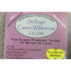
Adirondack Paddler’s Map – Close-up Series: St. Regis Canoe Wilderness, 2nd edition
Part of the Adirondack Paddler’s Map series. Full color, shaded relief and topographic map at a 1:31,250 scale (Approx 1″ = 0.5 miles). Shows private land, state land, wilderness designated lands, portages, trails, numbered campsites, and UTM Grids. Measurements are in metric.
Waterproof and tear-resistant material. “18 x 24″ format folded to approximately 4 x 9.”
Covers these areas:
- St. Regis Wilderness
- St. Regis Lakes
- Paul Smiths Area
- Upper Saranac Lake
- Floodwood/Fish Creek Area
- Raquette River from Stony Creek to Tupper Lake
Be the first to review “Close-up Series: St Regis Canoe Wilderness”
Related products
New


Original price was: $304.00.$97.99Current price is: $97.99.
New

Sunglasses
Original price was: $164.99.$95.99Current price is: $95.99.
New

Original price was: $14.00.$9.80Current price is: $9.80.
New

Sunglasses
Original price was: $18.00.$12.60Current price is: $12.60.
New

Original price was: $15.00.$10.50Current price is: $10.50.
New

Sunglasses
Original price was: $274.95.$96.99Current price is: $96.99.
New

Original price was: $382.00.$97.99Current price is: $97.99.
New

Sunglasses
Original price was: $35.00.$24.50Current price is: $24.50.
Reviews
There are no reviews yet.