
![National Geographic Trails Illustrated Allegheny South [Allegheny National Forest] -Outdoor Products Store 868t8V5QQlOZIkNTzNiQ 14 0f88b305 1029 415e 91a5 39b48d59b8d2](https://www.camp-equipment.com/wp-content/uploads/2025/07/868t8V5QQlOZIkNTzNiQ_14_0f88b305-1029-415e-91a5-39b48d59b8d2-100x100.webp "National Geographic Trails Illustrated Allegheny South [Allegheny National Forest] 1")
![National Geographic Trails Illustrated White Mountain National Forest West [Franconia Notch, Lincoln] -Outdoor Products Store H0XZRuSwQ4WPLyZEDSBL 15 ba0ab5ad fd7a 43d3 baf5 6f725a7981e5](https://www.camp-equipment.com/wp-content/uploads/2025/07/H0XZRuSwQ4WPLyZEDSBL_15_ba0ab5ad-fd7a-43d3-baf5-6f725a7981e5-100x100.webp "National Geographic Trails Illustrated White Mountain National Forest West [Franconia Notch, Lincoln] 2")


Original price was: $14.95.$10.47Current price is: $10.47.
- Best price, safe shopping guarantee
- Quality You Can Count On
- Quality and Affordability Combined
- Free and fast shipping worldwide

• Waterproof • Tear-Resistant • Topographic Map
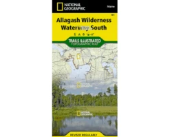
Expertly researched and created in partnership with local land management agencies, National Geographic’s Trails Illustrated map of Allagash Wilderness Waterway South provides an unparalleled tool for exploring this majestic 92-mile-long ribbon of rivers, lakes, ponds, and streams that winds through the heart of the North Maine Woods. This map is loaded with valuable information such as watercraft regulations, rules for recreational use and access, river difficulty scale, checkpoints, visitor and ranger station locations, and more. Some of the key areas of interest included are Eagle, Chesuncook, Chamberlain, Allagash, Caucomgomoc, Moosehead, and Seboomook lakes; Gero Island; Bear Mountain; Big Reed Forest Reserve; St. John Pond; and Big Spencer Mountain.
Year-round activities abound in the region and the location of boat launches, canoe carry downs, scenic viewpoints, lookout towers, and other points of interest are clearly marked as are park and forest boundaries and access points. Campers will appreciate the attention paid to noting the variety of camping facilities available including primitive campsites, group campsites, campgrounds, picnic areas, restrooms, parking, and trailheads. Whether paddling the Northern Forest Canoe Trail, camping in the North Maine Woods, or driving the Maine Scenic Byway, this map performs as a highly functional travel tool that is as useful as it is remarkably crafted. The map base includes contour lines, shaded relief, and elevations for summits and many lakes.
Every Trails Illustrated map is printed on “Backcountry Tough” waterproof, tear-resistant paper. A full UTM grid is printed on the map to aid with GPS navigation.
Other features found on this map include: Caucomgomoc Lake, Chamberlain Lake, Chesuncook Lake, Eagle Lake, Seboomook Lake.
Be the first to review “National Geographic Trails Illustrated Allagash Wilderness Waterway South”
Related products


Sunglasses


Sunglasses


Sunglasses


Sunglasses


Reviews
There are no reviews yet.